Friday, September 9, 2011

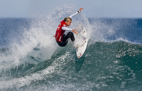
Australian Wins Surfing Competition

by Mike Pesca

Australian Owen Wright won the first pro-surfing competition held in New York. Wright beat out Kelly Slater, a ten-time world champion surfer, for the $300,000 prize

Monday, September 5, 2011

Kitesurfing makes it possible to stay in the water all day

Surfersvillage Global Surf News, 2 September, 2011 : - - There’s a bunch of ways to surf. The way you do it may differ from the traditional surf, to windsurf, kite, bodyboard, bodysurf, kneeboard, paddle surf, and all of these are constantly developing new surfing techniques. In fact, experienced surfers can improve their skills by combining other sports. Learning a similar surf sport can be a way of “getting out of the box” and trying new things on top of a board.
“For example you can upgrade your surf skills by learning how to do kite, and the other way around, as kite surfers can always learn how to surf and increase their kite skills”, says Joao from Surf’inn Surfcamps. “We at Surf’inn, are driving this trend offering packages to both experienced and beginners that combine accommodation with kite & surf lessons”.
These water sports need different natural conditions but Lagos has unique geographic conditions to combine surf, kite, windsurf and wakeboard just a few minutes away from each other! From perfect waves to consistent thermal winds and flat water.
Joao also says that the combination of both surf and kitesurf is also a way to maximize the time spent on surfing holidays. “We always expect weather conditions to be perfect for surf or kite, but these are always changing, being impossible to predict what the weather will be like. So, if you are adaptable you can always take advantage of what the weather will be”.


For more information visit:

Sunday, September 4, 2011

Australia: Search for great white after surfer killed

GEORGIA LONEY, The West Australian

The 21-year-old bodyboarder killed by a shark near Dunsborough yesterday was dead before fellow surfers could drag him ashore.

Police say the man was surfing at Bunker Bay with a mate when he was attacked just after 1pm, about 1km from the Bunkers Beach Cafe.

Dunsborough Sgt Craig Anderson said the Wilyabrup man was among a group of about five men surfing in an area known as The Boneyards.

"Out of nowhere it would appear that the young fellow has been taken by a shark," he said. "No one saw the shark itself but they've observed the young fellow's body in the water in amongst some blood.

"His mate and someone else that was surfing with him have pulled the body ashore, emergency services have been notified, but unfortunately the nature of the injuries mean the young fellow was deceased before he was pulled from the water."

Sgt Anderson described the young man who pulled his fatally injured friend ashore as heroic.

"You have to take your hat off to the young fellow who was surfing with him and his mate for bringing him ashore, the nature of his injuries were significant," he said.

Sgt Anderson said local residents had described yesterday's weather as "perfect shark conditions".

"It was dark and gloomy water, overcast skies, light rain falling, there was whale action in the bay and some seals about," he said.

He said the dead man was from the Eastern States and had been working in various jobs in WA for the past three or four years.

Despite a search, the shark had not been seen and the beach would stay closed.

He said a vessel would sweep the area today.

Onlookers said they believed the shark was a 4.5m great white.

Bunkers Beach Cafe manager Hamish McLeay said the cafe was full when the attack happened.

"We had a restaurant full of people, a beach full of people, great surf, beautiful day, typical South West day, then the word got out that someone had been taken by a shark, it's one of our favourite spots down the beach," he said.

"Everyone is saying you have more risk of being hit by a car or stung by a bee, it's one of those things . . . it's very unusual." It is the second fatal shark attack in the South West in the past year.

Last August, Busselton man Nick Edwards, 31, was taken by a shark while he surfing at Gracetown.

Shark expert Hugh Edwards said the Cape Naturaliste to Cape Leeuwin area was a "travel route" for sharks, particularly great whites.
"The risk of being attacked while in the water is very low but there's no doubt that there are far more people in the water in these areas than there were 10, 20 years ago so we are seeing more attacks," Mr Edwards said.

Friday, September 2, 2011

Tropical Storm Lee forms off US Gulf


By JANET MCCONNAUGHEY - Associated Press
NEW ORLEANS (AP) — A large storm system churning in the Gulf Of Mexico grew Friday into Tropical Storm Lee, beginning a holiday weekend-long assault that could bring up to 20 inches (50 centimeters) of rain in some spots from Louisiana to the Florida Panhandle.

The storm was expected to make landfall on the central Louisiana coast late Saturday and turn east toward 

New Orleans, where it would provide the biggest test of rebuilt levees since Hurricane Gustav struck during the Labor Day holiday in 2008.

Governors in Louisiana and Mississippi, as well as the mayor of New Orleans, declared states of emergency. 

Officials in several coastal Louisiana communities called for voluntary evacuations.

Residents who have survived killer hurricanes such as Katrina in 2005 didn't expect Lee to live up to that legacy.

"It's a lot of rain. It's nothing, nothing to Katrina," said Malcolm James, 59, a federal investigator in New Orleans who lost his home after levees broke during Katrina in August 2005 and had to be airlifted by helicopter.

"This is mild," he said. "Things could be worse."

Lee comes less than a week after Hurricane Irene killed more than 40 people along the East Coast and knocked out power to millions. It was too soon to tell if Hurricane Katia, out in the Atlantic, could endanger the U.S.

By Friday evening, the outer bands of Lee, the 12th named storm of the Atlantic hurricane season, already began dumping rain over southeastern Louisiana, southern Mississippi and Alabama.

The storm's biggest impact, so far, has been in the Gulf of Mexico oil fields. About half the Gulf's normal daily oil production has been cut as rigs were evacuated, though oil prices were down sharply Friday on sour economic news.

Federal authorities said 169 of the 617 staffed production platforms have been evacuated, along with 16 of the 62 drilling rigs. That's reduced daily production by about 666,000 barrels of oil and 1.7 billion cubic feet of gas.

Tropical storm warning flags were flying from Mississippi to Texas and flash flood warnings extended along the Alabama coast into the Florida Panhandle. Lee had winds of 40 miles (64 kilometers) per hour — minimal tropical storm strength.

The National Hurricane Center said the center of Lee was about 185 miles (295 km) southwest of the mouth of the Mississippi River on Friday and moving north at just 2 mph (4 kph). Its center was expected to make landfall in Louisiana over the weekend.

Forecasters say that Lee's maximum sustained winds have increased to 45 mph (75 kph), from 40 mph (65 kph), and could increase further.

In New Orleans' central business district, Friday seemed a typical day. Employees at big-box home improvement stores said residents weren't rushing in to stock up on supplies.

Merchants, however, worried the storm would dampen the Southern Decadence festival, an annual gay lifestyle fixture that rings cash registers on Labor Day weekend. Ann Sonnier, shift manager of Jester's bar, said receipts were disappointing so far.

"People are probably scared to death to come here after Katrina," she said.

Saturday, August 27, 2011

Seven-metre waves hit Hawaii surf event

by Russell Jackson
Australia's world No.1 Joel Parkinson has described the scenes at Teahupoo on Saturday (Sunday AEST) as the "craziest" he's ever seen during his many years coming to the powerful Tahitian break.
The surf became so dangerous, the Tahitian government issued a 'code red', blocking day eight of the Billabong Pro from commencing as waves up to seven metres battered the tiny village.
"It feels like it's going to get bigger and bigger throughout the day," Parkinson told AAP.
"I would hate to go out there. I was enjoying watching but that was it. I saw three or four of the most hideous wipeouts that I've ever seen. Guaranteed, it's the craziest I've seen it."
One local surfer was taken to hospital with a suspected broken leg while others have been smashed into the reef and suffered bad cuts.
The swell has been so fierce that waves have been rolling onto people's front lawns and members of the media have been warned their media hut could be flooded and to be ready to evacuate.
World tour veteran Chris Davidson, from North Narrabeen, has been coming to Teahupoo for 15 years and the scenes on Saturday have blown his mind.
"I haven't seen it like this before," he said.
"It's looking pretty rough and tough and even the local boys said then it's not ideal and they've found it a bit hard and nobody has made that many out there.
"It's not perfect like it gets, that swell is coming from a long way and it's looking a bit junky out there.
"If we had to go and surf today, whatever, we would, but they're not going to run in this stuff. Hopefully it settles down tomorrow."
© 2011 AAP

Parkinson suffers rankings blow in Taiti


Australian surfer Joel Parkinson looks set to have surrendered his world number one ranking after he was dumped out in the second round of the Billabong Pro at Teahupoo in Tahiti.
It was a very poor day for Australia's big guns, with fifth-ranked Taj Burrow also eliminated from the competition.
Current number two Jordy Smith is now in the box seat to claim top spot following Parkinson's defeat, with the South African already into third-round action after his opening heat win.
Parkinson went for broke a couple of times on heavy waves but crucially faltered and, in the end, could only manage a 5.03 and a 5.30 for a combined score of 10.33.
Meanwhile, world number 25 Brett Simpson had a 7.67 and a 5.67 for a score of 13.34.
"I took one wave I probably shouldn't have and then I didn't make a really good one and that was it," Parkinson said.
"The wind makes it tough, it's been howling for a few days and there is a real slop on the ocean out there."
He added: "There are really good waves out there and I almost had one but it just cleaned me up at the end.
"It's that sort of place where sometimes you can be an inch away from perfection."
A swell of up to five metres has been forecast for Saturday, with organisers expected to put the competition on hold while big-wave surfers take over with a tow-in expression session.

Thursday, August 25, 2011

Irene: Surfs Up!


Surfs up, Irene is right at your door. Florida lucked out and won't see landfall, looks like the eye is going to pass offshore. But the waves, wind and rip currents should be brutal.

Weather experts warn people away from the surf this weekend
By TOM BARTON

Emergency management and National Weather Service officials warned boaters in Beaufort County to stay off the water and swimmers to stay out of the water Friday and Saturday in preparation for Hurricane Irene’s passage this weekend.

Waves and rip currents were already increasing Thursday afternoon on the beaches of Hilton Head Island.

Meteorologists and the Coast Guard warn Hurricane Irene could bring gale force winds to the South Carolina coast and inland waters will be choppy.

The agency increased its alert level for the state’s coast and advised large vessels to make preparations to leave or to let the Coast Guard know they are staying the Irene approaches. Boaters should also make sure small boats are moored properly, and recommends those living on houseboats seek shelter on land.

The National Weather Service issued a tropical storm watch for the coastal waters of Beaufort and Jasper counties.

A tropical storm watch means conditions with winds between 39 and 73 mph are expected within 48 hours.

“Mariners should not venture out Friday and Saturday,” said Steve Rowley, a meteorologist with the National Weather Service in Charleston. “Cancel any plans you have for fishing expeditions. Let this thing pass by. By Saturday afternoon and evening things should start to improve. Things will deteriorate from here on out for coastal waters. Anyone heading into or out of Beaufort County by boat needs to rethink their plans.”

Swimmers, as well, should stay out of the water, Rowley said.

The weather service and Town of Hilton Head Island issued warnings Thursday saying wind and waves breaking in excess of five feet pose a high risk for strong rip currents, which could be life threatening.

Rip currents are narrow, powerful channels of water that drag swimmers away from shore. They happen most often at low spots or breaks in the sandbar and around structures such as groin, jetties and piers.

People should stay off those structures as well, Rowley said. High waves could easily break over them and wash people out to sea, he said.

Swimmers were already being cautioned at the beaches on Hilton Head Thursday afternoon, as currents and waves began to pick up.

“We’ve been tossing flags up constantly today,” said Mike Wagner, manager of operations for Shore Beach Service. “The waves are definitely stronger than usual. We’ve called people in if they’re any farther out than waste-deep water. If you’re not a good swimmer, you should stay out of the water all together.”

The high surf could also cause some minor flooding at high tide in shallow areas along the coast and beach erosion, Rowley said.

Scott Liggett, director of public facilities and projects for Hilton Head, said residents and visitors should expect changes on the beach, including the island’s heel.

Work is slated to begin in early October to pump about a million cubic yards of sand onto a mile-long stretch of beach at Port Royal Plantation to combat a decade of erosion that has claimed about 100 feet of beachfront per year.

“Whether we replace sand lost from high waves caused by Irene will be driven based on need and budgetary concerns and constraints,” Liggett said. “We will see some erosion and sand moved around with the passage of the storm, but it’s hard to quantify what that will be.”

Irene is projected to be about 250 miles out to sea when it passes by the area Friday night into Saturday morning before possibly making landfall near North Carolina’s Outer Banks on Saturday afternoon, with winds around 115 mph.

The storm pounded the Bahamas early Thursday with widespread damage reported on at least two southern islands. It was a powerful Category 3 hurricane with winds at 115 mph. Forecasters said winds will ramp up quickly over the next day and Irene was expected to blow into a Category 4 with winds at least 131 mph.